For decades, efforts to save the hawksbills have focused primarily on safeguarding the eggs and ensuring that hatchlings survive and grow to eventually form a viable population. No one knows where these ancient mariners go after the nesting season, or where they forage as juveniles and adults.
Research elsewhere have shown that whilst some populations of hawksbills nest on nearby beaches fringing coral reefs, others migrate hundreds to thousands of kilometres in search of sponges at distant foraging grounds. Where do hawksbills that nest on Melaka’s shores swim off to after nesting? Where do they feed? Do they forage in Malaysian waters or migrate to distant coral reefs in neighbouring waters to live?
This lack of information hampers efforts to plan for turtle conservation. Satellite tracking of Melaka’s hawksbills using transmitters is one of the ways that will enable us to find out more about these gentle and beautiful mariners to effectively conserve them for our future generations.
|
|
Tracking Hawksbills by satellite
WWF-Malaysia is using satellite telemetry to track hawksbills on the journey back to their feeding grounds. Marine turtles are only dependent on the beach for egg incubation and spend most of their lifetime in coastal waters, feeding in coral reefs. Results from this research are crucial for a better understanding of their post-nesting movement and habitat use.
The project is tracking hawksbills to:
- establish the migration route and feeding ground of the hawksbills to facilitate the protection of their habitat;
- communicate migration routes and distant foraging grounds of hawksbills to relevant regional Memoranda of Understanding (MoUs) and Agreements so as to enhance regional marine turtle conservation strategies and partnerships (e.g. Indian Ocean-Southeast Asia Marine Turtle MoU and MoU on ASEAN Sea Turtle Conservation and Protection); and
- educate and create awareness among local schoolchildren in the coastal areas, based on satellite telemetry of turtles.
How Satellite Tracking Works |
| Satellite telemetry allows researchers to track sea turtles in the open ocean by attaching a Platform Transmitter Terminal (PTT) to the shell of a turtle. The PTT transmits signals to an orbiting satellite each time the turtle surfaces for air. The satellite sends the data on to a receiving station on earth that researchers can access on their computers. Find out more |
How are satellite transmitters deployed on sea turtles? |
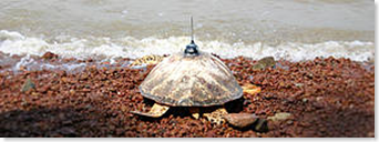
| The KIWISAT 101 (a model of satellite transmitters designed for marine tracking) is hydrodynamically shaped and weighs a minute 630g. It is attached to the turtle's carapace (shell) with dental putty (the stuff used to make dental impressions) as a base and encased using epoxy adhesive. The whole process (including the preparation of the carapace and taking necessary measurements) can be completed within 3 hours in which the turtle will be safely released after. The attachment is intended to be an impermanent fixture as it is meant to be easily removed if encountered after the usefulness of the device has expired or eventually detach itself due to prolong deterioration of the adhesive. |


0 comments:
Post a Comment